Palestine and Syria: Handbook for Travelers
The view of the valley of the Jordan is finest in the evening, but Jerusalem (from the Mount of Olives) is best seen in the light of the rising sun. The hill should therefore certainly be visited twice, especially as an interesting walk to the S. as well as to the N. can be taken.
A carriage-road leads from the Damascus Gate into the valley of the Kidron. We, however, start from St. Stephen's Gate (p. 75), outside of which we perceive, to the right (S.), the wall of the Temple, with Muslim graves in front of it. Ascending a few paces to the left, we observe a small pond, 31 yds. long, 25 yds. wide, and 13 ft. deep , in the corners of which are remains of stairs. At a niche in the S.W. corner the water is drawn off into a channel for the supply of the Bath of Our Lady Mary (Hammûm Sitti Maryam), whence the reservoir is called Birket Sitti Maryam. The style of the construction points to a comparatively modern, or perhaps mediaeval origin. The pond is sometimes called Birket el-Asbût, 'Dragon Pool', and 'Hezekiah's Pool, names for which there is no authority. The road forms an angle to the N.E.; the footpath to the right is a steep and stony short-cut. At the point where the routes re-unite, there is. a rock where the stoning of St. Stephen is said to have taken place. In 5 min. more we reach the bottom of the valley, which we cross by the upper bridge. (For the valley of the Kidron see p. 94.)
To the left of the road, beyond the bridge, is the chapel of the Tomb of the Virgin, where, according to the legend, she was interred by the apostles, and where she lay until her 'assumption'.
The story that a church was founded here by the Empress Helena is quite unfounded. It is, however, ascertained that a church stood over the traditional tomb early in the 5th century. This was destroyed by the Persians , but `Omar found that a 'church of Gethsemane' had again sprung up. We are informed that, at a later period, the church consisted of an upper and an underground story. The Crusaders found nothing but ruins here. The church was then rebuilt by Milicent (d. 1161), daughter of Baldwin II., and wife of Fulke of Anjou, fourth king of Jerusalem. At that period there was also a monastery in the vicinity. This church of the 12th cent, is still in tolerable preservation. It has frequently changed hands , but now belongs to the Greeks , the Latins having a slight share in the proprietorship.
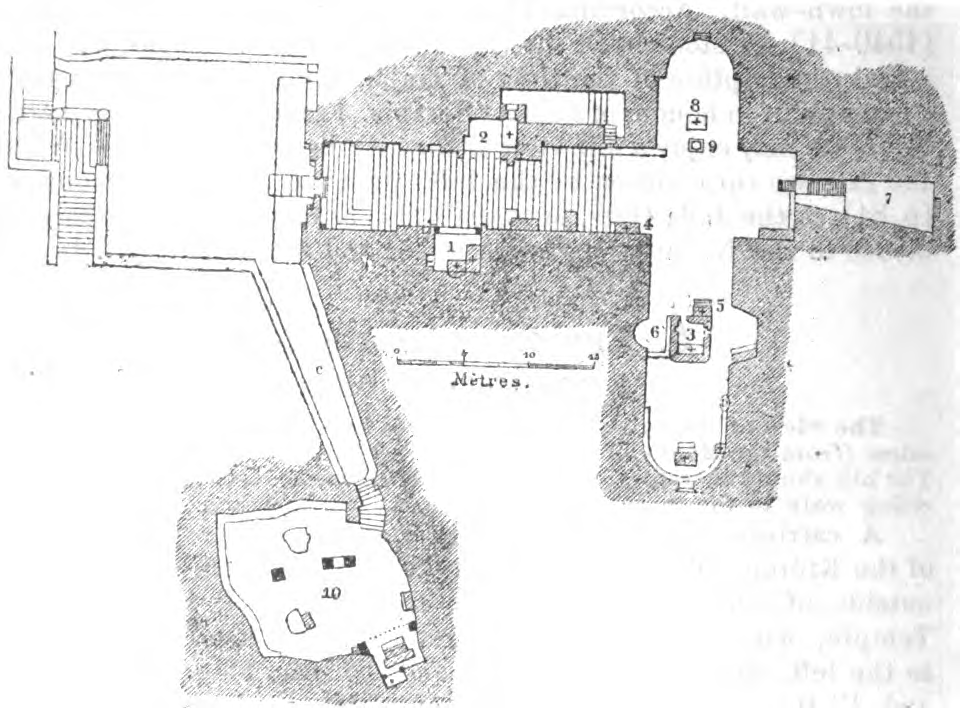
1. Tomb of Mary's Parents. 2. Joseph's Tomb. 3. Sarcophagus of Mary. 4. Altar of the Greeks. 5. Altar of the Armenians. 6. Prayer Recess of the Muslims. 7. Vaults. 8. Altar of the Abyssinians. 9. Cistern. 10. Cavern of the Agony.
A flight of steps descends to the space in front of the church. The only part of the church above ground is a porch. The principal facade is on the S. side, which is flanked by two flying but tresses , and in the middle has a portal with a beautiful pointed arch, into which a wall with a small door has been built. The arches rest on four marble columns. Visitors knock when the iron gate is closed. A handsome flight of 47 marble steps, which is more than 19 ft. broad at the top, descends immediately within the portal to a depth of 35 ft. below the space in front of the church. In descending we first observe a walled-up door to the right. This formerly led to a cavern, supposed to have been the scene of Our Lord's 'bloody sweat' ('Antrum Agoniæ), or perhaps to the tomb of Milicent, as the old descriptions appear to indicate. Then, about halfway down, there are two side-chapels. That on the right (PI. 1) contains two altars and the tombs of Joachim and Anna, the parents of the Virgin. The transference of these tombs hither from the church of St. Anne seems to have taken place in the 15th cent, but the traditions regarding them have since been frequently varied (comp. p. 76). The chapel to the left (PI. 2) contains an altar over the tomb of Joseph. The subterranean church is 31 yds. long, from E. to W., and 6 1/2 yds. wide. The E. wing, which is much longer than the W., has a window above. The church is lighted by numerous lamps. In the centre of the E. wing is the so-called Sarcophagus of Mary (PI. 3), a lofty sarcophagus in a small square chapel, resembling that in the Church of the Sepulchre. Here, too, a rock-tomb is said once to have existed. There are several other altars in the church. On the E. side is the altar of the Greeks (PI. 4), on the N. that of the Armenians (PI. 5). To the S. of the tomb is a prayer recess of the Muslims (PI. 6), who for a time had a joint right to the sanctuary. 'Omar himself is said once to have prayed here, in 'Jezmânîyeh' (Gethsemane). Opposite the stairs, to the N., are vaults of little importance (PI. 7). The W. wing contains an altar of the Abyssiniahs (PI. 8), in front of which is a cistern (PI. 9) with fairly good water, considered by the Greeks and Armenians to be a specific against various diseases.
On our return to the upper forecourt we observe to the left (E.) a passage (PI. c) leading to a cavern, the entrance to which is closed by a small door mounted with iron. A descent of six steps leads us into the so-called Cavern of the Agony ('Antrum Agoniæ', PI. 10), about 18 yds. long, 9 1/2 yds. broad, and 12 ft. high, and lighted by a small opening above. This is a genuine grotto in the solid rock, although whitewashed at places. The ceiling, on which, particularly towards the E., there are still traces of old frescoes, is borne partly by natural pillars, and partly by masonry. The cavern contains three altars belonging to different confessions, and several broad stone benches. The hole in the ceiling would appear to indicate that the grotto was originally a cistern or an oil-press. —
A few paces from the Tomb of the Virgin, towards the S. , on the opposite side of the road leading to the Mt. of Olives, is situated the Garden of Gethsemane, a word signifying 'oil-press'.
In this case, the tradition tallies with the Bible narrative. The festive crowd assembled on the occasion of the Passover would be little disposed to descend the precipitous slope of the valley, and the neighbourhood of the garden was then, as now, but little frequented. The earliest account of the place which we possess dates from the 4th century. At one time it was of greater extent and contained several churches : and chapels. The scene of the arrest of Christ was pointed out in the middle ages in the Cavern of the Agony (see above), and the traditions regarding the various sacred places here fluctuate. The garden now belongs to the Franciscans.
The entrance is from the E. side , i.e. the side next the Mt. of Olives. A rock immediately to the E. of this door marks the spot where Peter, James, and John slept (Mark xiv. 32 f.). Some ten or twelve paces to the S. of this spot, and still outside the garden-wall, the fragment of a column indicates the traditional place where Judas betrayed Jesus with a kiss, an event which was formerly said to have happened in the grotto. — The present Garden of Gethsemane is in the shape of an irregular quadrangle, the diameter of which is about 70 paces. On the inside of the walls are pictures of the 14 stations. The garden contains eight venerable olive-trees, which are said to date from the time of Cnrist ; their trunks have split with age and are shored up with stones. The monk who acts as guide presents the visitor with a bouquet of roses, pinks, and other flowers, as a memento of the place, and expects 3-6 pi. for the maintenance of the garden. The olive-oil yielded by the trees of the garden is sold at a high price, and rosaries are made from the olivestones.
Farther up the Mt. of Olives is the Greek garden of Gethsemane, with the Church of St. Mary Magdalen, built in the Russian style, with 7 tapering domes, erected in 1888 by the Russian Emperor.
Three roads lead from the garden of Gethsemane to the Mt. of Olives, one of which starts from the S. E. and another from the N.E. corner, the latter soon again dividing. At this point, about thirty paces from the garden, there is situated, on the right, a light grey rock, which has been pointed out since the 14th cent, as the place where the Virgin on her assumption dropped her girdle into the hands of St. Thomas. Close by is a small Russian hospice. Several Christian graves were discovered here, one of which yielded a silver coin of King Baldwin. — The central path, which soon diverges to the right, is the steepest. About halfway up, a ruin on the left has been shown since the 14th cent, as the spot where 'when he was come near, he beheld the city, and wept over it' (Luke xix. 41). The spot commands a beautiful view of the city. Even the Muslims once regarded the scene of the Weeping of Christ as holy, and a mosque stood here in the 17th century ; at present the Franciscans have built a chapel here. — The top of the Mt. of Olives is reached from Gethsemane in 1/4 hr.
The Mt. of Olives (Mons Oliveti, Arab. Jebel et-Tûr), or Mt. of Light, as it is sometimes called, runs parallel with the Temple hill, but is somewhat higher. It consists of several different strata of chalky limestone, over which there are newer formations at places. The Mt. of Olives, in its broadest sense, includes the Mt. of Offence (p. 96), to the S., and to the N. an eminence sometimes erroneously designated as Scopus. The Mt. of Olives proper is divided into four eminences, by low depressions. The highest point, to the N. ('Viri Galilæi', p. 93), is 2723 ft. above the sea-level. The slopes are cultivated, but the vegetation is not luxuriant. The principal trees are the olive, fig, and carob, and here and there are a few apricot, terebinth, and hawthorn trees. The paths are stony, and the afternoon sun very hot. — On the W. side of the two central summits lies Kafr et-Tûr which is mentioned for the first time in the 15th cent, and now consists of poor stone cottages, whose inhabitants are sometimes importunate.
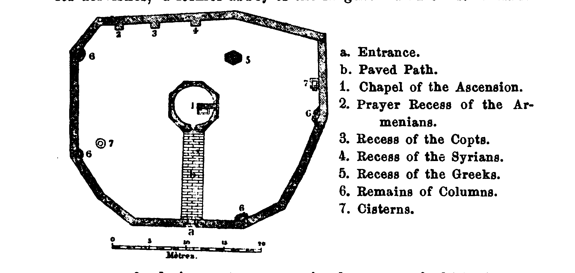
a. The Chapel of the Ascension. — History. The tradition which makes the Mt. of Olives the scene of the Ascension is contradicted by the passage in St. Luke — 'he led them out as far as to Bethany'' (xxiv. 50); moreover, the summit of the mount was at that period covered with buildings. As early as 315, however, the top of this hill was pointed out as the scene of that event, Constantine erected a basilica here, but without a roof, and the footprints of Christ were pointed out on the ground. About the year 600 many monasteries stood on the mount. In the 7th cent, there was a small round church here, which had been built by Modestus, but was destroyed in the 11th century. The Crusaders are said to have erected 'only a small tower with columns, in the centre of a court paved with marble; and the principal altar stood on the rock within'. In 1130 a large church rose on this spot, having in the centre a broad depression marking the scene of the Ascension, below which was a chapel. After the time of Saladin we find the chapel enclosed by an octagonal wall. In the 16th cent, the church was completely destroyed. In 1617 the interior of the chapel was restored by the Muslims in the original style, and in 1834-35 the building was re-erected on the former ground-plan.
a. Entrance.
The Chapel of the Ascension stands by the side of a monastery for dervishes, a former abbey of the Augustinian monks. A handsome portal admits us to a court, in the centre of which rises the chapel of irregular octagonal shape, 21 feet in diameter, over which rises a cylindrical drum with a dome. Over the corner pilasters once rose open pointed arches, but these are now built up. The capitals and bases of the columns are of white marble and have probably been brought from older buildings. In an oblong marble enclosure is shown the impression of the right foot of Christ, turned southwards. Since the time of the Frankish domination this foot print has been so variously described, that it must have been frequently renewed since then. The chapel belongs to the Muslims, who also regard it as sacred, but Christians are permitted to celebrate mass in it on certain days.
In the S.W. corner of the monastery of the dervishes is a door leading to the Vault of St. Pelagia (Arab. Râhibet Bint Hasan). The door opens into an anteroom, whence twelve steps descend to a tomb-chamber, now a Muslim place of prayer, and uninteresting.
The Jews place here the tomb of the prophetess Huldah (2 Kings xxii. 14), and the Christians the dwelling of St. Pelagia of Antioch, who did penance here for her sins in the 5th cent., and wrought miracles even after her death. The tradition as to Pelagia dates from the Crusaders' period.
b. The Russian Buildings, to the E. of the village, are reached by going northwards from the Chapel of the Ascension and round the N. side of the village. In the garden, which is surrounded by a high wall, we first see a handsome church, erected after the design of the old church, the remains of which were found here. To the left (N.W.) of it is a hospice for pilgrims; to the N. of the church is the large, six-storied Belvedere Tower, from the platform of which (214 steps) we have a magnificent View (comp. the Panorama). Beyond the valley of the Kidron extends the spacious plateau of the Harâm esh-Sherif , where the dome of the rock and the Aksa mosque present a particularly imposing sight. The spectator should observe the direction taken by the Temple hill, the higher site of the ancient Bezetha to the N. of the Temple, and the hollow of the Tyropœon, which is plainly distinguishable, though now filled with rubbish, between the Temple hill and the upper part of the town. The dome-covered roofs of the houses form a very peculiar characteristic of the town. Towards the N., beyond the olive-grove outside the Damascus Gate, is seen the upper course of the valley of the Kidron, decked with rich verdure in spring, beyond which rises the Scopus. — The view towards the E. is striking. Here, for the first time, we perceive that extraordinary and unique depression of the earth's surface which few travellers thoroughly realise. The blue waters of the Dead Sea, lying at the foot of the mountains which bound the E. horizon, and apparently not many hundred feet below us, are really no less than 3900 ft. below our present standpoint. The clearness of the atmosphere, too, is so deceptive, that the mysterious lake seems quite near, though it can only be reached after a seven hours' ride over barren, uninhabited ranges of hills. The blue mountains which rise beyond the deep chasm, reaching the same height as the Mt. of Olives, once belonged to the tribe of Reuben, and it is among these that Mt. Nebo must be sought for. To the extreme S. of that range, a small eminence crowned by the village of El Kerak (p. 178) is visible in clear weather. On the E. margin of the Dead Sea are seen two wide openings ; that to the S. is the valley of the river Arnon (Môjib) , and that to the N. the valley of the Zerkâ Ma'in. Farther N. rises the Jebel Jil'ad (Gilead), once the possession of the tribe of Gad. Nearer to us lies the valley of Jordan (el-Gh6r), the course of the river being indicated by a green line on a whitish ground. — Towards the S.E. we see the course of the valley of the Kidron, or 'valley of fire', to the left some of the houses of Bethany, the greater part of the village being, however, concealed by the hills; high up, beyond Bethany the village of Abu Dîs. Quite near us rises the 'mountain of offence', beyond the Kidron that of 'evil counsel', and farther distant, to the S., is the summit of the 'Frank Mountain', or Jebel el-Fureidis, with the heights of Bethlehem and Tekoah. To the S.W., on the fringe of hills which bounds the plain of Rephaim on the S., lies the monastery of Mâr Elyâs, past which winds the road to Bethlehem. This town itself is concealed from view, but the large village of Bêt Jâlâ and several villages to the S. of Jerusalem, such as Bêt Safâfâ and Esh-Sherâfât, are distinctly visihle.
Eastwards, behind the church, is the house of the archimandrite. In building this house, some interesting mosaics were found, which are now preserved in one of the rooms ; beneath this room is a sepulchral chamber. There are similar mosaics in the vaulted chambers and tomb discovered to the S. of the house. The mosaics contain Armenian inscriptions of the 9th and 10th centuries: all of them are relics of an Armenian monastery.
c. The Latin Buildings are S. of the village. (Before we come to them from the village a road to Bethany branches off on the left, see p. 93 ; the central of the three roads on the right leads into the valley of Kidron.) To the right behind the entrance (on the W. side) is the place where the apostles are said to have drawn up the Creed. The tradition regarding the creed , which was once said to have been framed in the town, was attached to this new spot in the 14th cent., and in the 15th cent, a 'Church of St. Mark' rose here. The low-lying Church of the Creed situated from N. to S ; it is now vaulted over, but so that the roof forms a terrace only slightly raised above the surface of the ground. At the sides are niches which once bore twelve arches, and at the N. end two pointed arches are still preserved. To the S. is the house of the superintendent, to whom application should be made for admission to the church ; the chaplain's house adjoins the north wall. — Behind the Church of the Creed, to the E., is the beautiful Church of the Lord's Prayer, on the spot where, according to a tradition of the Crusaders' period, Christ taught his disciples the Lord's Prayer. Peter of Amiens preached a sermon here, and a church was then erected. In 1868 the Princess Latour d'Auvergne, relative of Napoleon III., caused a church to be erected here. Around the handsome quadrangle run covered passages containing 32 slabs, on which the Lord's Prayer is inscribed in as many different languages. On the S. side the princess has a monument with a life-size effigy erected to her memory. Adjoining the Hall of the Lord's Prayer on the E. is the church, the antechamber of which contains antiquities discovered when the foundations of the church were laid , including a leaden coffin and numerous fragments of mosaics. — To the N. of the church is a convent of Carmelite nuns.
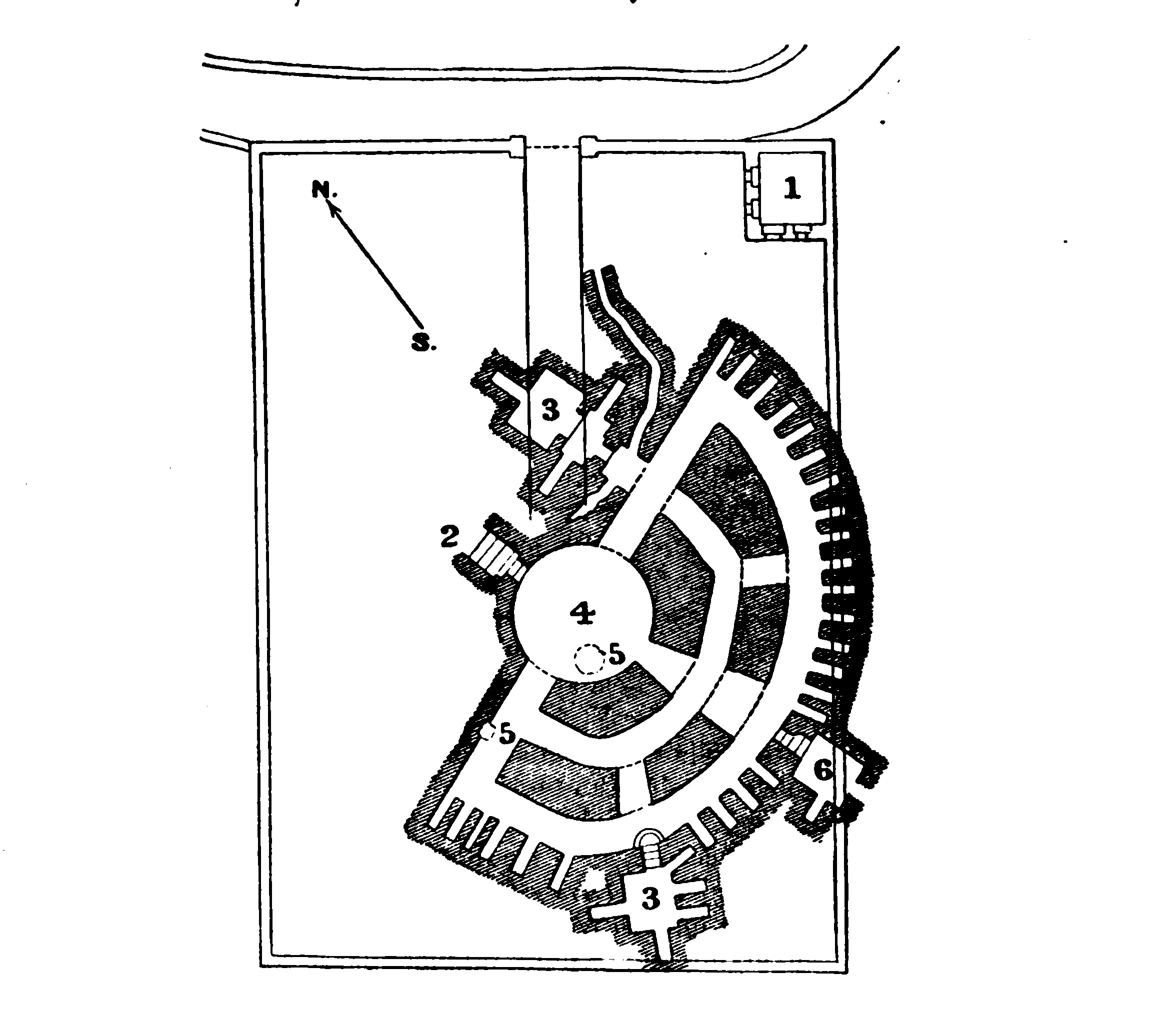
d. To the S.W. of the Latin buildings lie the Tombs of the Prophets, or the Small Labyrinth, now Russian property. We take the road to the S. past the Latin buildings; at the point where the road takes a turn to the N.W. is the entrance. Application for admission should be made to the custodian (PI. 1; candle necessary). We descend a few steps (PI. 2) and enter, through a low arch hewn out in the rock, a Rotunda- (PI. 4) lighted from above. Some passages radiate from the rotunda into the rock, and are intersected by two semicircular passages in such a manner, that large natural rocky pillars are formed, some of whioh are 33 yds. in circumference. The passages are uneven and partly filled up. The wall of the outermost of these passages contains numerous shaft-tombs (p. cxi). To the N. and S.W. are two small chambers (PI. 3); a third (PI. 6) is unfinished. This is a very fine example of an ancient rock-tomb. The rough way in which the chambers are hewn points to a very early origin , but there is no historical authority for connecting them in any way with the prophets. That they belong to the Jewish period is proved by the form of the receptacles for the dead (kôkîm). The Jews have a great veneration for these tombs. Greek inscnptions, however, are to be found in them, which show that the tombs were at least made use of afresh in Christian times.
Close to the E. girdle-wall is a narrow aperture in the rook, through which we may visit a small tomb- chamber with a number of niches, discovered in 1847, at which time the bodies, covered with lime, were still lying there untouched. To the W. is another chamber, of a roundish form, roughly hewn in the rock, containing nine sunken tombs, all close together. To the E., adjacent to these, is another fine tomb-chamber.
e. The fourth (N.) summit of the Mt. of Olives, at a distance of 1/4 hr. from the village Et-Tûr, is called Viri Galilæi (Arab. Karem es-Sayyâd, 'the vineyard of the hunter'). The first name it owes to the tradition that the 'men of Galilee' were addressed here on the spot marked by two broken columns by the two men in white apparel after the Ascension (Actsi. 11). This tradition was current in the 13th cent. , but was not firmly established till the 16th. The passage Matth. xxvi. 32 was also interpreted to mean that Christ had appeared here. Extensive ruins once lay here, and some pilgrims even mention a village. The greater part of the area now belongs to the Greeks, who have erected a chapel, a small episcopal residence, and other buildings. Towards the S. traces of a Christian burial-ground (remains of the wall, fragments of columns, mosaic pavement with 15 graves beneath it) were discovered. Under the present E. wall of the area an extensive burial-place, consisting of Jewish and Christian rock-tombs (possibly the Peristereon of Josephus), was found. The antiquities are preserved in the bishop's house.
From this point we may either return direct to the Garden of Gethsemane or, turning to the N. and following the top of the hill, perform the circuit of the valley of the Kidron. The valley gradually expands. At the point where the hill turns towards the N.W. it is called 'Akabet es-Sûwân. Passing Mr. Gray Hill's villa, we reach the road leading from Jerusalem to 'Anâtâ, (p. 116). The view of the town from the brink of the plateau is interesting, as its position on the top of a rocky eminence is distinctly seen, and its indented N. wall, resembling that of a mediaeval fortress, its towers, and its numerous mosques and minarets appear to great advantage. — In 1/2 hr. we reach the N.E. corner of the town-wall. The ancient tower here is called Burj Laklak ('Stork Tower'). Ancient tombs may be seen by the large pine of Karem esh-Shêkh. We reach the Jericho road at the recently restored Gate of Herod, named by the Arabs Bâb es-Sâhireh (p. 31).
From the 'Anata road we may cross the hills to the Nâbulus road on the W. To the E. of this road, near the spot called by the Arabs Meshârif ('hills'), was situated the Scopus, where Titus and his legions once encamped.
f. Bethphage. From the village Et-Tûr the road to the S.E. mentioned on p. 91 brings us in 1/2 hr. to Bethany (p. 148). On this road Bethphage (Mark xi. 1) was situated, on the ridge of a small hill, about 10 min. E. of the Latin buildings. At any rate the ruins found here in 1880 and a stone with frescoes (Christ's Entry into Jerusalem, Raising of Lazarus) and inscriptions show that the Crusaders believed this to be the site of Bethphage. The Franciscans have built a chapel over the stone on the ruins of a small ancient church.