August 6: Two ambulances were sent to the hotel for our party and Adjutant General Ruggles, who is here on a tour of inspection. Mark rose early and said he would walk to the fort slowly, he thought it would do him good. General Ruggles and the ladies went in one ambulance, the old four mule army officers ambulance, and the other waited some little time before starting that I might complete arrangements for all the party to go direct from the fort to the depot.
The Butte, Anaconda and Pacific Railway is a short line railroad in the U.S. state of Montana which was founded in 1892. It was financed by the interests behind the Anaconda Copper Mining Company, (Daly and JJ Hill), and operated primarily to carry copper ore from the mines at Butte, Montana to the smelters at Anaconda, Montana, although the company was chartered as a common carrier and also carried passengers and general freight.
The Panic of 1893 was a serious economic depression in the United States that began in 1893 and ended in 1897. It deeply affected every sector of the economy and produced political upheaval that led to the 1896 realigning election and the Presidency of William McKinley. The Sherman Silver Purchase Act of 1890, perhaps along with the protectionist McKinley Tariff of that year, has been partially blamed for the panic. Passed in response to a large overproduction of silver by western mines, the Sherman Act required the U.S.
Samuel Thomas Hauser, territorial governor of Montana from 1885 to 1887, formed the Missouri River Power Company in 1894 and won the approval of the United States Congress to build a dam, the Hauser Dam, two miles below Stubb's Ferry on the Missouri River. It was a steel dam built on masonry footings on top of gravel, with the ends of the dam anchored in bedrock on either side of the river. The dam was 630 feet long and 75 feet high.
Egbert Malcolm Clark(e) arrived in the upper Missouri region in the 1840's with a reputation for violence. He had been briefly enrolled at West Point but was quickly expelled for assaulting a classmate. President Andrew Jackson reportedly intervened and Clarke was reinstated only to be court martialed for another attack on a classmate. He had been in the Texas Army and worked for the American Fur Company. Eventually he owned property along what had been the Mullan Military Road.
James Jerome Hill, primary stockholder and president of the St. Paul, Minneapolis & Manitoba Railway (StPM&M), established the Montana Central Railway on January 25, 1886. Few railroads served Montana at that time. But Butte, Montana, was a booming mining town that needed to get its metals to market; gold and silver had been discovered near Helena; and coal companies in Canada were eager to get their fuel to Montana's smelters.
Clemens with kittens and the little girl's family. Norwegian Shanty Town. Great Falls, Montana. July 31
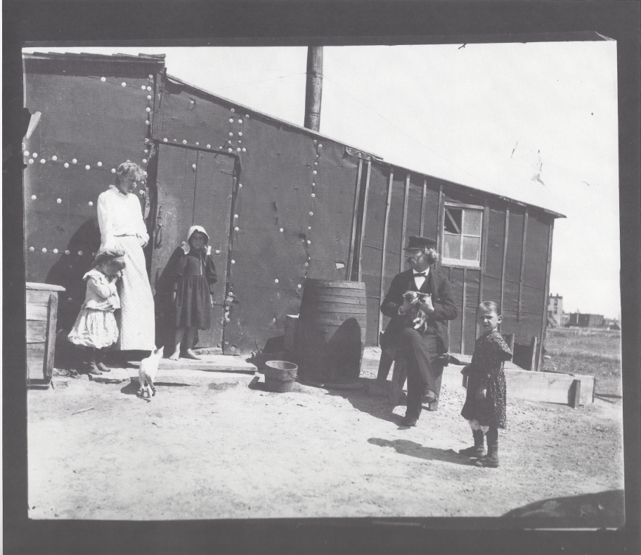
Mark Twain Archive, Elmira College courtesy of Kevin Mac Donnell, Austin, Texas.
Following the Civil War, hostilities continued with the Sioux until the 1868 Treaty of Fort Laramie. By 1868, creation of new territories reduced Dakota Territory to the present boundaries of the Dakotas. Territorial counties were defined in 1872, including Bottineau County, Cass County and others. During the existence of the organized territory, the population first increased very slowly and then very rapidly with the "Dakota Boom" from 1870 to 1880. Because the Sioux were considered very hostile and a threat to early settlers, the white population grew slowly.
July 29 Monday - From J.B. Pond's diary: We have been in Crookston, Minn., all day, where we were the first and especially favored guests of this fine new hotel. "Mark Twain's" name was the first on the register. We are enjoying it. "Mark" is as gay as a lark, but he remained in bed until time to go to the Opera House. This city is wonderfully improved since I was
The Lake Superior and Mississippi Railroad, created in 1863, was the first rail link between the Twin Cities and Duluth. Financier Jay Cooke had selected Duluth as the northern end of the new railroad. Lyman Dayton, a local businessman put up $10,000 of his own money to do the original surveying work and served as the railroad's president until his death in 1865. It was completed in 1870, running through the city of Carlton and along the path of the Saint Louis River to Duluth. Later that year the first passenger trains started running between the Twin Cities and Duluth.
Subscribe to
© 2026 Twain's Geography, All rights reserved.