16 July, 1867 Twain and 5 companions departed Genoa by train, arriving in Milan that evening. The capital of Lombardy, Milan united with Italy in 1861. Twain spent two days touring the city. He returned, with his family for a week in September of 1878. Twain devotes much of chapter 18 of The Innocents Abroad on the Cathedral of Milan. ""Everything about the huge edifice impressed Mark Twain." (Mark Twain A to Z) See:
Well provided with cigars and other necessaries of life, we are now ready to take the cars for Milan. All day long we sped through a mountainous country whose peaks were bright with sunshine, whose hillsides were dotted with pretty villas sitting in the midst of gardens and shrubbery, and whose deep ravines were cool and shady and looked ever so inviting from where we and the birds were winging our flight through the sultry upper air. We had plenty of chilly tunnels wherein to check our perspiration, though. We timed one of them.
Arriving in Genoa
In due time the shores of Italy were sighted, and as we stood gazing from the decks, early in the bright summer morning, the stately city of Genoa rose up out of the sea and flung back the sunlight from her hundred palaces. Here we rest for the present—or rather, here we have been trying to rest, for some little time, but we run about too much to accomplish a great deal in that line.
The Women of Genoa
VERSAILLES! It is wonderfully beautiful! You gaze and stare and try to understand that it is real, that it is on the earth, that it is not the Garden of Eden—but your brain grows giddy, stupefied by the world of beauty around you, and you half believe you are the dupe of an exquisite dream. The scene thrills one like military music!
What excellent order they kept about that vast depot! There was no frantic crowding and jostling, no shouting and swearing, and no swaggering intrusion of services by rowdy hackmen. These latter gentry stood outside—stood quietly by their long line of vehicles and said never a word. A kind of hackman general seemed to have the whole matter of transportation in his hands. He politely received the passengers and ushered them to the kind of conveyance they wanted, and told the driver where to deliver them.
Toward nightfall the next evening, we steamed into the great artificial harbor of this noble city of Marseilles, and saw the dying sunlight gild its clustering spires and ramparts, and flood its leagues of environing verdure with a mellow radiance that touched with an added charm the white villas that flecked the landscape far and near. [Copyright secured according to law.]
At this present moment half a dozen of us are taking a private pleasure excursion of our own devising. We form rather more than half the list of white passengers on board a small steamer bound for the venerable Moorish town of Tangier, Africa. Nothing could be more absolutely certain than that we are enjoying ourselves. One can not do otherwise who speeds over these sparkling waters and breathes the soft atmosphere of this sunny land. Care cannot assail us here. We are out of its jurisdiction.
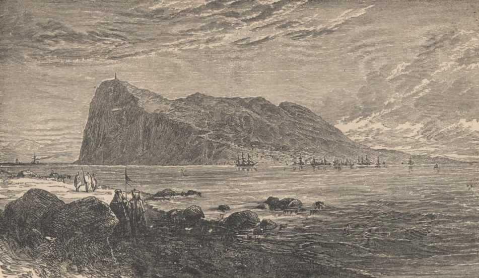
In a few moments a lonely and enormous mass of rock, standing seemingly in the center of the wide strait and apparently washed on all sides by the sea, swung magnificently into view, and we needed no tedious traveled parrot to tell us it was Gibraltar. There could not be two rocks like that in one kingdom.
Within the hour we were fairly within the Straits of Gibraltar, the tall yellow-splotched hills of Africa on our right, with their bases veiled in a blue haze and their summits swathed in clouds—the same being according to Scripture, which says that “clouds and darkness are over the land.” The words were spoken of this particular portion of Africa, I believe. On our left were the granite-ribbed domes of old Spain. The strait is only thirteen miles wide in its narrowest part.
A week of buffeting a tempestuous and relentless sea; a week of seasickness and deserted cabins; of lonely quarterdecks drenched with spray—spray so ambitious that it even coated the smokestacks thick with a white crust of salt to their very tops; a week of shivering in the shelter of the lifeboats and deckhouses by day and blowing suffocating “clouds” and boisterously performing at dominoes in the smoking room at night.
Subscribe to
© 2026 Twain's Geography, All rights reserved.