Palestine and Syria: Handbook for Travelers
The Valley of the Kidron, now called Wâdi Sitti Maryam, or valley of St. Mary, bounds Jerusalem on the E. side. The floor of the valley deepens somewhat rapidly. The upper part is broad and planted with olive and almond trees, while the lower part is narrower.
As early as the time of Christ the Kidron was called the 'winter brook', and at the present day the valley is always dry above the springs which we are about to mention. By way of contrast to the mount of the Temple, this valley was regarded as unclean. The name of `Valley of Jehoshaphat' is of early origin, having been already applied to this valley by the venerable pilgrim of Bordeaux. The tradition that this gorge will be the scene of the last judgment (p. 52), founded on a misinterpretation of a passage in the book of Joel (iii. 2), is probably of pre-Christian origin, and has been borrowed from the Jews by Christians and Muslims alike. The Muslims accordingly bury their dead on the E. side of the Harâm, while the Jews have their cemetery on the W. side of the Mt. of Olives. At the resurrection the sides of the valley are expected to move farther apart, in order to afford sufficient room for the great assembly. — Captain Warren's excavations have ascertained that the E. slope of the Temple hill is very deeply covered with debris, and was formerly much steeper than now. The ancient bed of the brook lies about 10 yds. to the W. of the present floor of the valley, and, opposite the S.E. corner of the Temple plateau, is about 38 ft. deeper than the present channel. Contrary to expectation, no water was found, but the soil in the ancient bed of the valley was moist and slightly muddy.
To the W. of Gethsemane a road branches off from the highroad to Jericho and leads to the right (S.W.) to the lower bridge. This bridge may also be reached by following the wall of the Harâm from the Gate of St. Stephen as far as the Golden Gate, and then descending into the valley to the left. The first tomb we come to, on the left of the road, is the Tomb of Absalom (Arab. Tantûr Fir'aun, 'cap of Pharaoh'), so called from , Sam. xviii 18.
There' is no mention of the monolith before the year A.D. 333. The names assigned to this and the other monuments vary down to the 16th century. The enrichments, and particularly the Ionic capitals, indicate that the tomb dates from the Greeco-Roman period; but the chamber may be older, and the decorations may have been added long after the first erection of the monument, a supposition favoured by the grotesque mixture of Greek and Egyptian styles. In memory of Absalom's disobedience, it is customary with the Jews to pelt this monument, with stones.
The substructure of this strange-looking monument is a large cube, 19 1/2 ft. square, and 21 ft. high. It is hewn out of the solid rock and is detached on three sides, being separated from the rock hy a passage 8-9 ft. wide. The E. side, however, is imbedded in rubbish. On each side of the rock-cube are four half-columns with very prominent capitals of the Ionic order, those on the W. front being best preserved. They bear, together with the corner pilasters, a frieze and architrave of the Doric order. As the surrounding rock was not high enough to admit of the whole monument being executed in a single block, a square superstructure of large stones was erected above the massive base. On this is placed a drum , terminating in a low spire which widens a little at the top like an opening flower. So far as it is visible above the rubbish, the monument is 48 ft. high. The proper entrance to the structure is imbedded in rubbish.
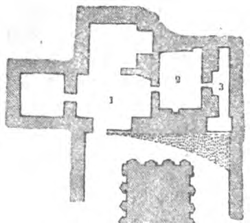
In the rock on the E. side , behind the Tomb of Absalom, is the Tomb of Jehoshaphat. The entrance is entirely choked with rubbish and surmounted by a kind of gable. The first chamber (PI. 1) is adjoined by three others, of which that on the S. side (PI. 2) has an additional cell of two compartments (PI. 3). The traces of a coat of mortar and of frescoes suggest that the principal chamber has once been used as a Christian chapel. It may possibly be the chapel which enclosed the tomb of St. James in the time of the Franks.
We proceed over the hill towards the S. to the Giotto of St. James, which is entered by a long passage, leading to a kind of vestibule (PI. 1). In front, towards the valley (W.), the vestibule is open for a space of 16 ft. and is borne by two Doric columns 7 ft. in height (PI. a), adjoining which are two side-pillars incorporated with the rock. Above these runs a Doric frieze with triglyphs ; over the cornice is a Hebrew inscription. We next enter an ante-chamber (PI. 2] towards the E. , and beyond it a chamber (PI. 3) with three shaft-tombs of different lengths; beyond which we ascend by several steps to a small chamber to the N.E. (PI. 4). To the N. of No. 2 is a chamber (PI. S) containing three shaft-tombs, and to the S. of it is a passage (PI. 6) with a shelf of rock, to which steps ascend ; above the shelf are four shaft-tombs. St. James is said to have lain concealed here from the taking of Jesus until the Resurrection, during which time he ate no food. This tradition, and another that he is buried on the Mt. of Olives, date from the 6th cent. , while another to the effect that this grotto is his tomb is not older than the 15th. Monkish preachers are said to have lived here for a time, hut the cavern was afterwards used as a sheep-pen.
From the vestibule of the Grotto of St. James a passage (PI. 7) leads southwards to the Pyramid of Zacharias , executed according to the Christians in memory of the Zacharias mentioned by St. Matthew (xxiii. 35), but according to the Jews in memory of the Zechariah of 2 Chron. xxiv. 20. The monument resembles Absalom's tomb, but is entirely hewn in the rock. This cutting in the rock is very remarkable. On the S. side are still seen the holes which probably supported the scaffolding of the masons. The monument is about 29 1/2 ft. high and 16 1/2 ft. square. The sides are adorned with Ionic columns and half-columns, and at the corners are square pillars. Above runs a bare cornice, over which rises a blunted pyramid. A great number of Hebrew names are inscribed on the monument. — All these rock-tombs were probably executed in the Graco-Roman period.
Above these monuments, to the E. , the whole hill is covered with Jewish tombstones, and we pass others on our way southwards to the village of Siloah (Arab. Silwân) , which we reach in 4 minutes. The village clings to the steep hill-side and, when seen from the opposite side, is not easily distinguished from the neighbouring rocks, which are of the same colour. The main street intersects the village from N. to S. ; it consists of about eighty houses, and miserable as is its appearance, there are many worse in Palestine. As many of the ancient caverns of the Jewish necropolis, which was formerly here, are now used as dwellings and stables, they cannot easily be examined. At the entrance to the village there is another monolith known as the 'Tomb of Pharaoh's Daughter' ; over the entrance are the remains of an inscription in ancient Hebrew letters. In the lower part of the cliff is a series of entrances to tombs, some of them artistically hewn. Still farther to the S., on the descent to Job's well, numerous remains of tombs are seen on the hill to the left. The inhabitants of Silwan, who are all Muslims, are notorious for their thievish propensities. They live chiefly by farming and cattle-breeding, and some of them bring water from the Siloah or Job's well on the backs of donkeys into the town for sale. They are easily induced by a small bakhshish to show the caves to visitors. Two early Hebrew inscriptions (now in London) were found in a rock -chamber here. These grottoes were once tenanted by hermits, and the Arabian village has only existed for a few centuries past. — Near Siloah is the house for lepers, erected by the Turkish government (p. 102).
The village lies on the slope of the S. eminence of the Mt. of Olives, called Bain el-Hawâ , and sometimes Mountain of Offence [Mons Offensionis, Mons Scandali), from 2 Kings xxiii. 13 ; but it is questionable whether there is any foundation for the story that this was the scene of Solomon's idolatrous practices , although they appear to he localised here hy the Vulgate. The top, which may be reached in 7 min., commands an interesting view, though very inferior to that from the Mt. of Olives. To the E. lies the Wâdi Kattûn, to the W. the valley of Jehoshaphat and to the S. the valley of the Kidron, or valley of fire.
From the N. part of the village of Siloah a road leads to the neighbouring (4 min.) St. Mary's Well, Arab. 'Ain Sitti Maryam, or 'Ain Umm ed-Derej (fountain of steps).
The name is derived from a legend of the 14th cent, to the effect that the Virgin once washed the swaddling clothes of her Son, or drew water here. It has also been called the Dragon's Well, or Well of the Sun. It is probably identical with the spring of Gihon (1 Kings i. 33). Gihon lay outside the walls of the city, and at various times efforts were made to render its water available for the inhabitants. Perhaps the earliest of these is the canal, discovered by Schick in 1891 and not yet fully excavated, which conveyed the water along the surface of the ground to the Pool of Siloam (p. 98). As this channel would be of little use in time of war, a subterranean passage was constructed (probably also under one of the early kings) from within the walls to a perpendicular shaft above the spring. An attempt to deprive enemies of the water was made by the construction of a subterranean channel (see below), which is very probably a work of Hezekiah (2 Kings xx. 20). The basin near the Gihon was also called the King's Pool (Nehem. ii. 14). The spring also watered the orchards in this part of the valley.
The entrance is to the W. of the remains of a small mosque. We descend by sixteen steps through a vault to a level space, and by fourteen steps more to the water. The basin is 11 1/2 ft. long and 5 ft. wide, and the bottom is covered with small stones. Tho spring is intermittent. In the rainy winter season the water flows from three to five times daily, in summer twice, and in autumn once only. This is accounted for as follows. In the interior of the rock there is a deep natural reservoir, which is fed by numerous streamlets and has a single narrow outlet only. This outlet begins a little above the bottom of the basin, rises to a point higher than the top of the basin, and then descends. As soon as the water in the basin has risen to the height of the bend in the outlet, it begins to flow through it, and continues to flow on the syphon principle until it has sunk in the basin to the point where the outlet begins. — A channel or passage descends to the lower pool of Siloam. This passage is of very rude construction and now (though not originally) of varying height, being so low at places as only to be passable on all fours. Curiously enough, it is not straight, but has several windings, and there are a number of small culs de sac in its course, apparently showing that the unskilled workmen had frequently lost the right direction. The distance in a straight line is 368 yds., but by the rocky channel 586 yds. As the water frequently fills the passage quite unexpectedly, it is dangerous to attempt to pass through it.
In 1880 the oldest Hebrew inscription we possess (now in Constantinople) was found at the mouth of this channel in the rock. It contains a brief account of the construction of this channel, 1200 ells long, and, among other details, mentions that the workmen began the boring from both ends. In consequence of this most important discovery, the channel was again examined, and the spot was found where the hoes of the diggers met. The shafts in a vertical direction, which have been discovered in the interior, are also very remarkable.
A path ascends from St. Mary's Well to the N., towards the S.E. angle of the Temple wall.
The Pool of Siloam or Siloah (Arab. 'Ain Silwân), farther down the valley, lay near the Fountain or Water Gate (p. 26), within the walls. From this point also a road ascends to the Gate of Zion and the Dung Gate. The pool is 52 ft. long and 18 ft. wide. In consequence of the miracle recorded by St. John (ix. 7t), the pool was deemed sacred. In the year 600 a basilica with baths stood over the pool, and in the 12th cent, a kind of monastery was erected here. The walls of the pool are now fallen in, and the bottom is covered with rubbish. At the S.E. angle of the pond there is an outlet. Excavations now being carried on by English explorers have here revealed the remains of a church with fine mosaics, traces of an ancient wall, a flight of steps cut in the rock, a paved street, etc. — The water is salt to the taste, perhaps from the decomposition of the soil through which it percolates. It loses itself in the gardens of the valley below. E. of the upper pool is the Lower Pool of Siloam, now dry. The Arabs call it Birket el-Hamrâ, or 'the red pool'. The oldest of the above-mentioned channels ends here. There was probably a double town wall in this vicinity. To the S. of the large pool stands an old mulberry-tree, enclosed by stones for its protection, and mentioned for the first time in the 16th cent., where the prophet Isaiah is said to have been sawn asunder in presence of King Manasseh. The tradition of this martyrdom is alluded to by some of the fathers of the church.
A road hence leads farther down the valley , reaching in a few minutes the junction of the valleys of Jehoshaphat and Hinnom. We follow the road to Mar Sâba (p. 161), which leads us in 2 min. to a spring called Job's Well (Bîr Eyyûb), from a late and senseless Muslim legend. The channel of the Kidron is at this point 345 ft. lower than the Temple plateau (near Gethsemane 145 ft. only), and Mt. Zion rises steeply on the N.W. Near the well is a ruined mosque. The well is lined with masonry, and is 123 ft. deep. The water varies greatly in height, sometimes overflowing after much rain, which is considered to indicate a fruitful year, and gives occasion for a general festivity; it very seldom dries up altogether, and is noted for its excellence. 'Job's Well' has been called the 'Well of Nehemiah' by the Frank Christians since the 16th cent., from the tradition that the holy fire was concealed in this well during the captivity until recovered by Nehemiah. Probably we are here standing on the brink of the well of En-Rogel ('fullers' spring'), mentioned (Josh. xv. 7) as the boundary between the tribes of Judah and Benjamin. Here, too, Adonijah prepared a feast for his friends on the occasion of his attempted usurpation of the throne of David (1 Kings i. 9). The modern Ez-Zahwêleh has of late been supposed identical with the 'stone of Zoheleth' mentioned in the latter passage, but the fullers' spring would then have to be placed nearer that of St. Mary. The question cannot be answered until it has been settled whether Job's well is of ancient or modern date.
About 20 min. from this point, on the hill to the S.E., is the village of Bêt Sâhûr el-`Atika, which consists of a few miserable hovels, but contains several rocky caverns and a pigeon-tower. Some flint implements were also found here. Along the whole N. and N.E. side of the hill of Bet Sahur are rock-tombs and large tomb-chambers, some with a handsome portal. Most of these tombs are probably to be referred to the Jewish epoch. The traces of oil-presses should also be observed. — For the return, we may take the Mar Saba road in the valley.